Turn by turn

Turn by turn Illinois Westbound Mt. Olive
Ordered from Eastbound to WestboundChange
Westbound Mt. Olive

Random point of interest

Sunflower Station

Sunflower Station

A fun and eclectic gift shop with local crafts and Route 66 souvenirs.

Detail

Westbound Mt. Olive

Printing this description can take a lot of time, so you might want to consider buying commercially available alternatives such as the 8 map set and the EZ66 guide to take along on your trip.
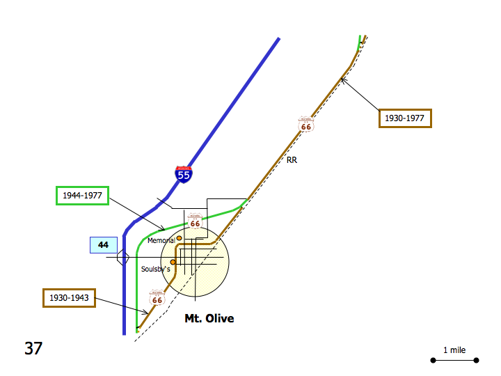
Map courtesy of Stefan Joppich – Legend

1926-1930 post 1930
Please see Gillespie. Continued from Litchfield.

Continue southwest on US-66 (BL-55)

Mt. Olive

As Route 66 veers right, away from the railroad, a choice of alignments is available:

1930-1943 post 1944
Left on Old Route 66.

Immediately right (=southwest) to stay with the railroad.

Curve right (=west) on 5th St.

Continue straight at the intersection with Lake St.

Right on Lake St. (CR-29).

Continue as Lake St renames to Mt. Olive Rd. (CR-29)

Union Miner’s Cemetry

Curve left (=south) onto Illinois St.

Continue straight at the intersection with Main St. (IL-138).

Soulsby Shell station

Continue as Illinois St. becomes Old Highway 66 and curves right (=southwest).

Continue to Staunton.

Continue straight on US-66.

Left on Mt. Olive Rd. (CR-29).

Union Miner’s Cemetry

Continue as US-66 curves left (=south).

Continue south on US-66.

Continue to Staunton.