Turn by turn

Westbound Staunton
Printing this description can take a lot of time, so you might want to consider buying commercially available alternatives such as the 8 map set and the EZ66 guide to take along on your trip.
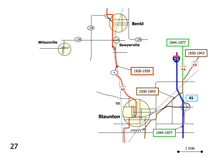
Map courtesy of Stefan Joppich – Legend
| 1926-1930 | 1930-1943 | post 1944 |
|---|---|---|
| Continued from Gillespie.
Continue south on Staunton Rd. (IL-4). EagervilleContinue south on Staunton Rd. (IL-4). Mt ClareLeft (=east) on Hardroad at the Intersection with Hardroad/Darsey St. (IL-138) Curve right (=south) with Hardroad. To west side of the street is Mt Clare, the east side is Benld. Right (=southwest) at the intersection with Walnut St. Immediately left (=south) on Hardroad (IL-4, IL-138) BenldContinue straight on Hardroad (IL-4) at the intersection with Central Ave. (IL-138). Continue south on Hardroad (IL-4). SawyervilleContinue south on IL-4. Left (=east) on Fritz Ln. (Old IL-4) as IL-4 starts to bend slight left. Follow Firtz Ln. (Old Il-4) as it bends right (=south). Left on IL-4. Continue south on IL-4. Continue south on IL-4. Follow as IL-4 curves left (=southeast) Cross over the railroad. Cross over the Cahokia Creek. Follow as IL-4 curves right (=south) StauntonContinue south on Edwardsville St. (IL-4) as the road renames. Curve right (=west) on North St. (IL-4). Immediately curve left (=south) on Hilbart St. (IL-4). Cross Main St. (CR-19). Right (=west) on Pearl St. (IL-4). Left (=south) on Hackman St. (IL-4). Curve right (=west) with Hackman St. (IL-4). Curve left (=south) with Hackman St. (IL-4). Continue south on IL-4. |
Continued from Mt. Olive.
Continue southwest on old Highway 66. Left (=south) on US 66 (E. Frontage Rd). |
Continued from Mt. Olive.
Continue south on US-66 |
|
Cross under the railroad. 0.5 miles south of the railroad overpass, a choice of alignments is available: |
||
| Right (=southwest) on Old 66.
Cross over I-55. Continue straight at the intersection with Staunton Rd. StauntonContinue on Historic Old Route 66. Curve left (=south) with the road onto Bentrup Rd. (Historic Old Route 66) Curve right (=west) onto Henry St. Next curve left (=soutwest) onto Old State Route 66i (Historic Old Route 66). Curve slight left on Madison St. (Historic Old Route 66). Continue as the road renames to Severs Rd. |
Continue straight on E. Frontage Rd (Double Arch Rd.)
Country Classic Cars Right on Staunton Rd. Cross over I-55. Enter I-55 southbound at exit 41. Continue south on I-55 till exit 30. |
|
