Turn by turn

Random point of interest
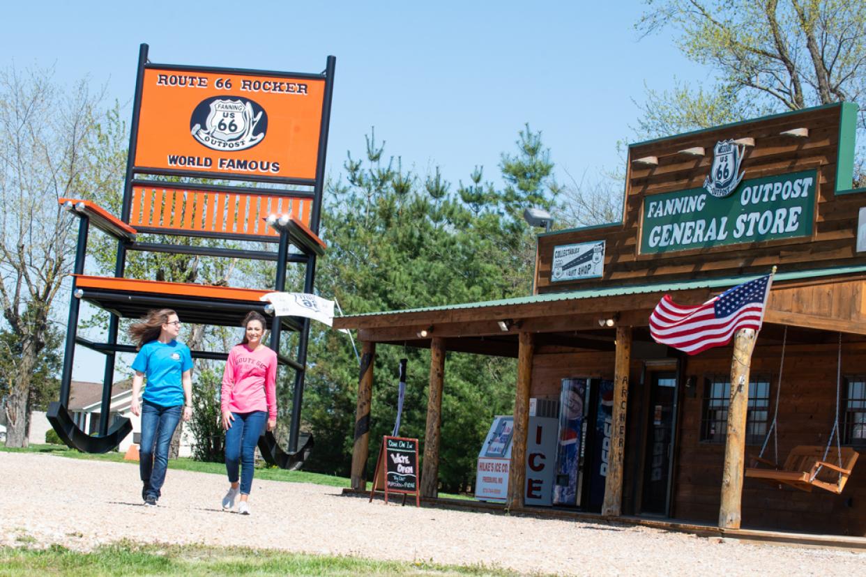
2nd Largest Rocking Chair
A great photo opp. This is the second largest rocking chair in the world.
DetailWestbound East Saint Louis
Printing this description can take a lot of time, so you might want to consider buying commercially available alternatives such as the 8 map set and the EZ66 guide to take along on your trip.

Map courtesy of Stefan Joppich – Legend
Warning: Some of the alignment choices have effects into Saint Louis, read ahead before making your choices as some might travel unpleasant neighbourhoods or dead-end on missing or undrivable bridges.
Do not despair if you don’t understand it all, many Route 66 experts get confused by (East) Saint Louis alignments. The best solution is to just pick an alignment and perhaps pick another one to get to some sites you want to see. The Chain of Rocks bridge is on the 1936-1955 alignment and while it dead-ends for motorized vehicles, it’s alomost a must-see.
| 1936-55 1955-65 Bypass |
1926-29 1929-35 Alt |
1929-36 1936-37 City |
1937-54 City | 1955-56 | 1957-61 1962-69 Bus |
post 1962 |
|---|---|---|---|---|---|---|
| Continued from Collinsville.
Continue west on Chain of Rocks Rd. MitchellCross the railroad tracks. Curve left (=southwest) onto Nameoki Rd. At the entry of exit 4 to I-270 a choice of alignments is available: |
Continue south on IL-111 next to Horseshoe Lake.
Continue straight at the intersection with Sand Prairie Ln. Cross under I-55/I-70. Fairmont CityRight on Collinsville Rd (The Historic National Rd.). |
Continued from Collinsville.
Continue west on Collinsville Rd. Fairmont CityContinue west on Collinsville Rd. |
Continued from Collinsville.
Continue on I-55. Fairmont CityContinue on I-55. East Saint LouisCross into Missouri on I-55 over the Poplar bridge. Continue to Saint Louis, MO. |
|||
| Left to enter I-270 westbound. [connecting]
We won’t get on I-270 before we exit already. Exit toward Old Afton Rd. [connecting] Right on Old Afton Rd. [connecting] In case you’re wondering why we do this: the railroads and I-270 cut through Chain of Rocks Rd. and part of the old road can actually be found just norh of here as a short stretch of Thorngate Rd. Cross under I-270. [connecting] Right after the entry to I-270 eastbound onto Chain of Roacks Rd. [connecting] Follow the curves as Chain of Rocks Rd. heads west again. Debby’s Route 66 Frozen Custard Continue straight at the intersection with IL-3. Continue over the Chain of Rocks Canal (no, this is not ‘the’ Chain of Rocks Bridge yet.) Continue west on Chain of Rocks Rd. The last road to the south leads to an area next to the river where you have a superb view on the bridge itself. dead-end To cross into Saint Louis: return on Chain of Rocks Rd. to IL-3, and take I-270 west to cross the Mississippi into Missouri. Continue to Saint Louis, MO. |
Straight ahead on Nameoki Rd. (IL-203).
Granite CityContinue as Nameoki Rd. (IL-203) veers left (=south). at the intersection with Madison Ave., a choice of alignments is available: |
|||||
| Turn right (=southwest) on Madison Ave.
Follow as Madison Ave. curves slight left. MadisonContinue south on Madison Ave. VeniceContinue right (=southwest) after the intersection with 2nd St. onto Broadway. Cross over the railroad yard. At the intersection with 4th St./Klein Ave. a choice of alignments is available: 4th St. is the fourth left you can make after crossing the railroad yard, take care as 5th St doesn’t exist here. |
Continue straight on Nameoki Rd. (IL-203).
Right (=southwest) on Edwardsville Rd. (IL-203). Cross the railroad tracks. MadisonContinue on Edwardsville Rd. (IL-203). Left (=south) on McCambridge Ave. (IL-203). Continue south on IL-203. Pass the Gateway International Raceway Avoid the onramps to I-55 and I-70. Cross over I-55/I-70. Right on Collinsville Rd. (The Historic National Rd.) |
|||||
| Continue straight on Broadway (IL-3) at the intersection with Klein Ave/4th St.
Curve slight right with IL-3 onto The great River Rd. Broadway does go on as a wide road, but it deadends on the the railroad. Cross under the railroad bridges. Next left to McKinley Bridge. Bridge closed: McKinley Bridge is closed for renovation, due to some setbacks the reopening has been postponed (last updated in 2006) Continue to Saint Louis, MO. |
Left (=south) on 4th St. (Il-3)
Right (=southwest) on 2nd St. (IL-3, The Great River Rd.). BrooklynContinue as 2nd St. (IL-3, The Great River Rd.) curves left (=southeast) East Saint LouisContinue as the road renames to St. Clair Ave. (IL-3) Cross under I-70/I-55. Please read the safety warning below before proceeding, to avoid that area, enter I-55/I-70 westbound. Continue on St. Clair Ave. (IL-3) Right (=southwest) on 9th St. (The Historic National Rd.) |
Continue on Collinsville Rd (The Historic National Rd.) | ||||
| Continue west on Collinsville Rd. (The Historic National Rd.).
Cross under the railroad. East Saint LouisContinue as the road become 9th St. (The Historic National Rd.). Cross over I-64 Please read the safety warning below before proceeding, to avoid that area: Continue straight on 9th St. |
||||||
|
unsafe area proceed at own risk. There were gang operated street blockades in this area in 2004. Continue on 9th St. (The Historic National Rd.). At the intersection with Martin Luther King Dr., a choice of alignments is available: |
||||||
| Continue straight (=southwest) on 9th St.
Left (=southeast) on Broadway. Right (=southwest) on 10th St. Cross under the interstate ramps. Bridge closed The ramp led to MacArthur Bridge. Return to I-55/I-70 and cross into Missouri. Continue to Saint Louis, MO. |
Route turned right one block further on Saint Louis Ave., but that is interrupted by I-55/I-70/I-64. Right (=northwest) on Martin Luther King Dr. Cross under I-70/I-55. Curve left (=west) on the on-ramp. Cross the Mississippi on Martin Luther King Jr. Memorial Bridge. Martin Luther King Jr. Memorial Bridge Continue to Saint Louis, MO. |
|||||
