Turn by turn

Random point of interest
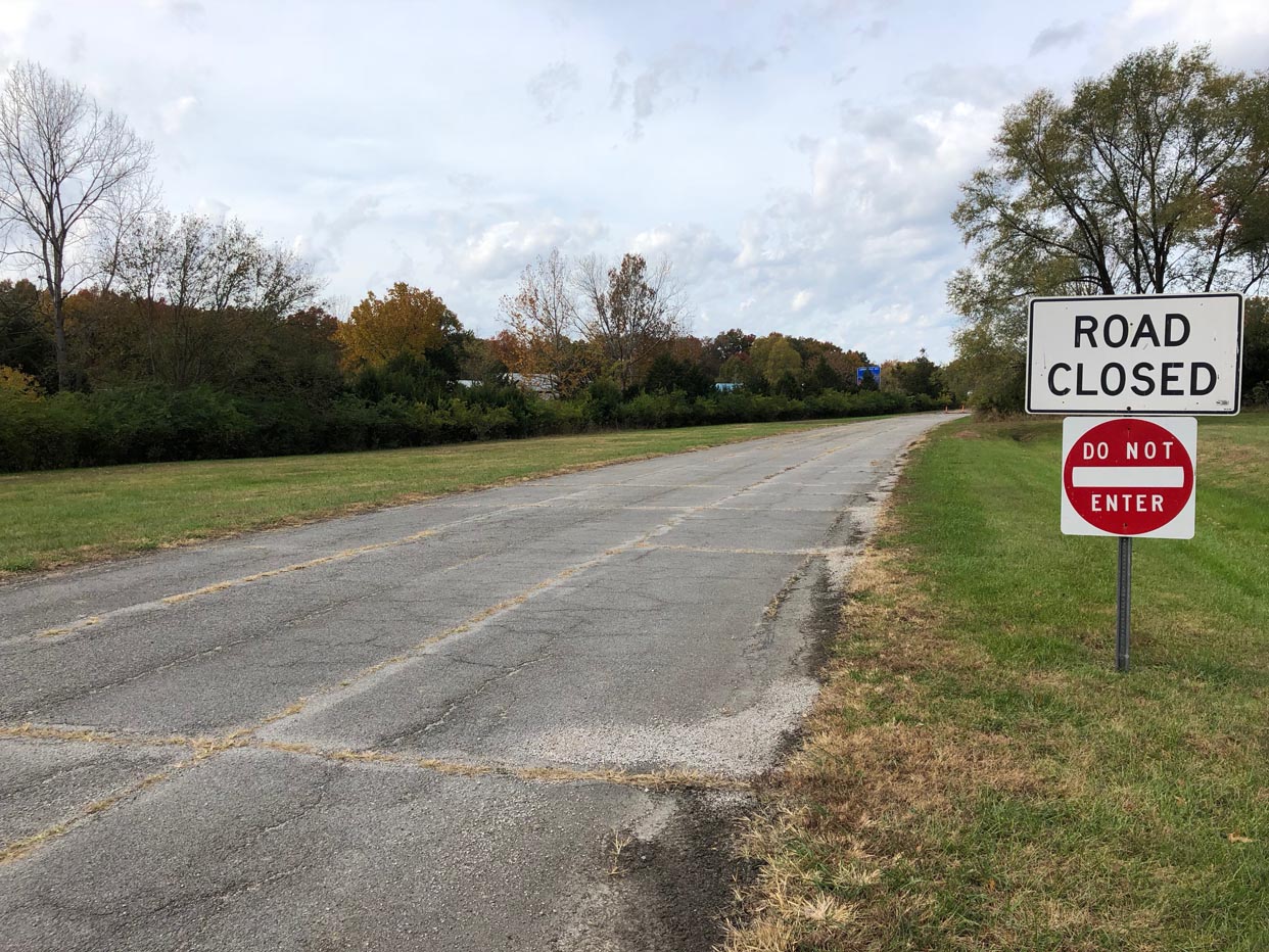
Route 66 State Park
Route 66 State Park is showpiece of environmental revitalization. It was originally the site of he ...
DetailChicago-Gardner
IllinoisPrinting this description can take a lot of time, so you might want to consider buying commercially available alternatives such as the 8 map set and the EZ66 guide.
Chicago
Over the years, Illinois has run a great program to sign Historic Route 66. You should find historic markers, not just for the latest version of the road, but also for older, almost forgotten alignments.
Mileage: 0
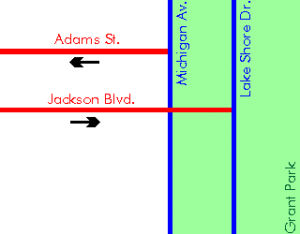
The start of Route 66 has moved a few times. Originally, Route 66 began on Jackson Blvd. at Michigan Ave. In 1937, the start (and end) was moved east onto the reclaimed land for the world fair to Jackson and Lake Shore Drive. In 1955, Jackson Blvd became one way west of Michigan Ave. and Adams St. became the westbound US-66. However, the start of US-66 remained on Jackson at Lake Shore Drive.
So, even while currently Adams Street at Michigan Avenue is marked as the starting point, Route 66 never departed from there.
The ending point is easier: post-1937 at Jackson Blvd. and Lake Shore Drive; prior to 1937 it was at the intersection of Jackson Blvd and Michigan Ave. (which is marked as the terminus).
Start from the intersection of Lake Shore Drive and Jackson Dr.
Take Jackson Dr. (west).
Buckingham fountain south of Jackson, built in 1927, is one of the Chicago landmarks.
Turn right (north) onto Michigan Ave.
Historic Santa Fe building, 224 S Michigan Avenue.
Historic Michigan Avenue, a one-sided street as a backdrop to Grant Park.
Turn next left (west) onto Adams Street.
Art institute: on Michigan Ave. just north of Adams
Orchestra Hall at the corner of Adams St. and Michigan Ave.
The EL (Elevated Train) Purple line at the beginning of Adams (Wabash Ave.).
Berghoff’s (German Restaurant) 17 W Adams St.
Sears Tower, opened in 1973, is located just before the Chicago river between Adams St. and Jackson Blvd at Wacker Dr. and Franklin St. The Skydeck can be visited for a fabulous view.
Cross over the South Branch of the Chicago River.
Union Station, at the intersection with S. Canal St.
Lou Mitchell’s Restaurant 565 W. Jackson Blvd, highly regarded among roadies. Open for (early) breakfast and lunch only.
Cross over I-90 (Kennedy Expy.).
Mileage: 2.6
After crossing Ashland Avenue, turn southwest (=left) onto Ogden Avenue.
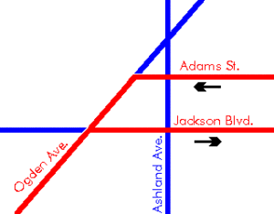
Continue on Ogden Ave. at the intersection with Western Ave.
Cross under the railroad tracks.
Ogden Ave. passes through Douglas Park, one of Chicago’s largest parks.
Site of the former Western Electric Hawthorne Works plant, on the right 0.25 miles west of Keeler Ave., once a workplace for 40,000 workers producing virtually all telephones made in the U.S.
Castle Car Wash at 3801 W Ogden Ave. (closed).
Cicero
Continue on Ogden Ave. under the Railroad interchange.
Cindy Lyn Motel, 5029 W Ogden Ave.
Henry’s Drive-In, the hot dogs here are famous for being a meal in itself. Located at 6031 W Ogden Ave.
Robin Hood Muffler Shop at 6131 W Ogden Ave.
Bunyon’s Hot Dogs (closed) on the north side of Ogden Ave. at Lombard Ave. This was the site of one of the muffler men, holding a giant hot dog. The muffler man is now relocated to Atlanta, IL. on Route 66 since 2003 after being in Cicero since 1963 at 6150 W Ogden Ave.
Cicero was in Al Capone’s days riddled with tunnels, used by gangsters and bootleggers. Cicero now is a clean place.
Berwyn
Continue on Ogden Ave.
Route 66 Beverages features a small mural, located at 6847 W. Ogden Ave.
Sidetrip: The Spindle, 8 cars on a 40-foot spike at the Cermak Plaza Shopping Center parking lot. Check also other artwork nearby, such as the Pinto Pelt: a Ford Pinto flattened against the wall. Site owner and sponsor is David Bermant.
Directions: Turn north onto Harlem Ave. for 1.8 miles, the Shopping Plaza is on the right just before the intersection with Cermac Rd. [Demolished on May 2nd, 2008]
The White Castle restaurant, home of the bite-sized sliders (slyders) at 7155 Ogden Ave. on the northeast corner at the intersection with Harlem Ave. This is a chain and you’ll find a few more as you drive.
Lyons
At the intersection with Harlem Ave (IL-43), a choice of alignments is available:
| pre 1928 | post 1928 |
|---|---|
| Continue on Ogden Ave. at the intersection with Harlem Ave.
Cross Pershing Rd. Cross the Des Plaines River. Continue on Ogden Ave at the intersection with Joliet Ave. On the right, you will see the Hoffman Tower and Dam, located on the waterfront at Barrypoint Rd. immediately after Joliet Ave. Continue as Ogden Ave turns slight left. Turn left onto Lawndale Ave. Cross 47th St. McCookTurn right on Joliet Rd. to rejoin the later alignment. |
Mileage:10 As you enter Lyons, turn south (=left) at the White Castle onto Harlem Avenue (IL-43).
Former Site of the Fairyland Park on West side of Harlem Avenue between 39th and 40th street (gone). Imagine having to pay to drive your own vehicle over a plank road called the ‘Whoopee Coaster’. After about 0.4 miles, turn southwest (=right) just past the Chevrolet dealer onto Joliet Road. Follow Joliet Road as it winds trough Lyons. Cross the Des Plaines River. McCookContinue straight at the intersection with Lawndale Ave. |
| Rejoin at the intersection of Joliet Rd. and Lawndale Ave., heading south on Joliet Rd. | |
Continue on Joliet Road.
Cross under IL-17.
Cross over the railroad tracks.
General Motors Electro-Motive on the right.
There is a detour south of Lyons, bear right onto 55th St. and turn next left onto East Ave. to rejoin Joliet Rd. after 0.5 miles. Joliet Road runs between two quarries, is structurally damaged and unlikely to reopen anytime soon.
Countryside
Continue on Joliet Rd.
Continue straight at the intersection with La Grange (US-45, US-20, US-12).
Wishing Well Motel on Joliet Road at Brainard Ave., built in 1941. Originally built as 10 cabins, later converted into one building with 19 rooms. There actually is a well in the yard of the motel. Address: 6305 S Brainard Ave.
Indian Head Park
Continue on Joliet Rd.
Burr Ridge
Continue on Joliet Rd.
Mileage:18
Pass under I-294 (Tri-State Tollway).
Enter I-55 at exit 277.
Joliet road disappears under I-55.
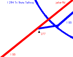
Exit immediately to North County Line Rd. at exit 276B.
Turn left onto Veterans Blvd. (formerly Case Dr.)
Turn next left onto Joliet Rd. (N. Frontage Rd.)
Willowbrook
Continue on Joliet Rd. (northern frontage rd.).
Dell Rhea’s Chicken Basket on the left before the intersection with IL-83, at 645 Joliet Rd.
Get back onto I-55 at exit 274.
Continue on I-55.
Darien
Continue on I-55.
Woodridge
Continue on I-55.
Bolingbrook
Continue on I-55 at the Intersection with I-355.
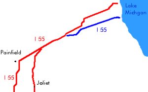
In 1940, Route 66 was realigned to pass through Plainfield and bypass Joliet. Multiple additional alignments were done over the subsequent years while building the Interstate – at the time called “freeway” – in accordance with a 1943 bill.
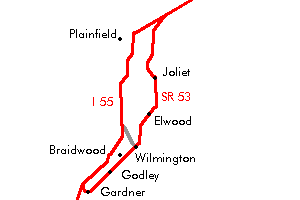
At the exit 268 on I-55, a choice of alignments is available:
| pre 1940 | post 1940 |
|---|---|
| Until 1940 this was the only Route 66 routing. After that, it became the ALT-66 routing.
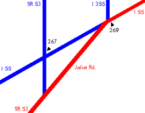
Mileage:26 Exit I-55 onto Joliet Road at exit 268.
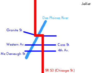
The map above says exit 269, this was correct when it was drawn in 1994, but exit 269 is now for I-355 only (a toll road), also note I-355 at the time did not continue south. At exit 268 (locally known as Welco Corners): Old gas station & Cafe and Montana Charlie’s Flea Market. White Fence farm, a restaurant on Joliet Road 2 miles after the I-55 exit, since 1954. Continue southwest on Joliet Rd. RomeovilleHistorical note: Originally Romeoville was called Romeo, but the love affair with Juliet seems to have ended when Juliet was renamed to Joliet. After about 3 miles since the I-55 exit, IL-53 joins Joliet Rd. Continue southwest on Joliet Rd / IL-53. Follow IL-53 as it turns south. Crest HillContinue on IL-53 southbound. JolietStateville Penitentiary. Enter Joliet on IL-53 (Broadway St.) Turn left onto Ruby St. Ruby Street Bridge over the Des Plaines River. Cross the Des Plaines River. Turn next right onto Chicago St. Follow IL-53 as it turns slightly right. Take a Right onto Jackson St. Immediately, take a left onto Ottawa St. Union Station at 50 E. Jefferson St. (US-30). Route 66 Welcome Center in the Joliet Area Historical Museum at 204 N. Ottawa St. Rialto Square Theatre at 102 N. Chicago. The Olde Keg at 20 W. Jackson St. (US-30). Follow US-6 as it turns left towards Chicago St. Follow Chicago St. south across I80.
Mileage:46 Just north of Elwood: after crossing Manhattan Rd. 1.5 miles later: turn left and right to change from the 4 lane alignment to the older 2 lane alignment. Look for old telephone poles! Follow Chicago St. (south). After 1.3 miles, turn right onto Mississippi Road (west). ElwoodAfter entering Elwood on Mississippi Rd., make a left onto Douglas St. Rejoin IL-53 south of Elwood. Joliet Arsenal: IL-53 crosses through the Joliet arsenal, a former ammunition plant and storage facility, now being returned to nature.
|
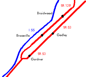
One could stay on I-55 and continue until Gardner or until the Wilmington exit. This way, one would still be following Route 66, but a later alignment. This alignment that passed through Plainfield was created in 1940. On I-55, take exit 261 towards Plainfield. PlainfieldIn Plainfield, turn left onto IL-59. Plainfield and Joliet both were on the Lincoln Highway, the first coast-to-coast highway designed for car travel built in 1915, later known as US-30. ShorewoodContinue on IL-59 Follow IL-59 south to enter I-55 southbound at exit 251. ChannahonContinue on IL-59 On I-55 at exit 238, exit onto IL-129 and continue towards Gardner. Southbound exit 238 appears to have been eliminated, take exit 240 instead, and follow the eastern frontage road toward IL-129 BraidwoodUntil Gardner, IL-129 runs parallel to the older alignment, but on the other side of the southern pacific railroad. GodleyContinue on IL-129 BracevilleContinue on IL-129 At the intersection with Main St. is your last chance to jump the tracks onto the other alignment. This alignment will dead end in less than 2 miles. When you are forced to turn west onto Huston Rd., away from the railroad, there is a short piece of overgrown road straight ahead, leading to a small hilltop overlooking a long gap where once a bridge stood that connected over the railroad joining from the north. Head back and cross the railroad to the other alignment. you can actually head back on the other side onto Il-129 till a roadblock preventing you from reaching the other side of the bridge that got torn down. |
| Continue on the pre 1940 aliggnment as we made you jump over to avoid a dead end. | |
Printing this description can take a lot of time, so you might want to consider buying commercially available alternatives such as the 8 map set and the EZ66 guide to take along on your trip.
Link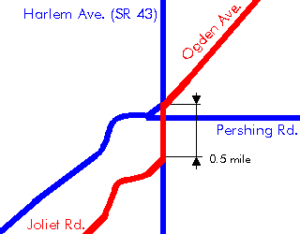
 Wilmington