Turn by turn
Westbound Hamel
Printing this description can take a lot of time, so you might want to consider buying commercially available alternatives such as the 8 map set and the EZ66 guide to take along on your trip.
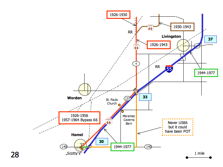
Map courtesy of Stefan Joppich – Legend
| 1926-1930 | 1930-1943 | 1944-1956 | post 1957 |
|---|---|---|---|
| Continued from Staunton.
Continue south on IL-4. Cross the railroad intersections. Continue south as Williamson Rd. joins us. |
Continued from Staunton.
Contineu south on Sievers Rd. Curve right (=west) onto Williamson Rd. Follow as Williamson Rd. curves left (=southwest) Left (=south) on IL-4. |
Continued from Staunton.
Continue south on I-55. LivingstonContinue south on I-55. Saint Pauls Church Meramec Caverns Barn HamelContinue south on I-55 till exit 30. A choice of alignments is available: Choose your alignments all the way into Saint Louis here. |
|
| Continue south on Il-4.
Right on Possum Hill Rd. (Frontage Rd.) [connecting]
Do not cross I-55. Next Left on W. Frontage Rd. Saint Pauls Church Meramec Caverns Barn HamelContinue as the frontage road renames to OLd US Route 66. Continue straight at the intersection with IL-140 onto IL-157 (Old US Route 66). |
|||
| Use exit 30 off of I-55.
Right (=west) on IL-140. Left (southwest) on IL-157 (Old US Route 66). |
Continue on I-55. | ||
| Continue on IL-157 (Old US Route 66) southwest.
Scotty’s |
|||


