Turn by turn
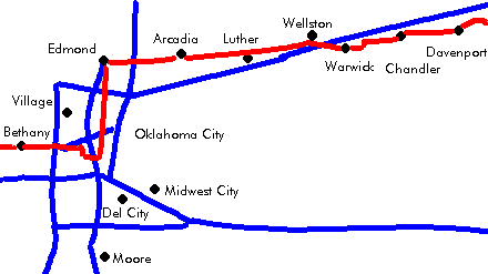
Davenport – Oklahoma City
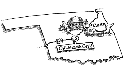
OklahomaPrinting this description can take a lot of time, so you might want to consider buying commercially available alternatives such as the 8 map set and the EZ66 guide to take along on your trip.
Davenport
Continue on OK-66 as it curves left onto Broadway (south).
Continue on OK-66 as it curves right onto 6th St. (west).
Sidetrip: Main St. is paved with bricks from a local making.
Continue on OK-66.
Chandler
Lincoln Motel on the right as you enter Chandler.
Continue on OK-66 as it curves left onto Manvel Ave. (OK-18) (=south).
Turn right at the south end of town onto 15th St, (OK-66, OK-18).
Straight across at the intersection with OK-18 onto OK-66 (15th St.).
Continue on OK-66 out of town.
Warwick
Continue on OK-66 as it curves left.
Pass under the railroad
Continue on OK-66 as it curves right.
Continue straight across the intersection with US-177.
Continue on OK-66 out of town.
Seaba Filling Station is located 1 mile beyond the intersection with US-177.
Wellston
Pass under I-44 near exit 158.
At the Y-intersection of OK-66 and Hayes Dr. (OK-66-BR):
| pre-1933 | post-1933 |
|---|---|
| Turn right onto Hayes Dr. (OK-66-BR).
Continue on OK-66-BR as it curves right onto Ash Ave. (OK-66-BR). Continue on OK-66-BR as it curves left onto 2nd St. (OK-66-BR). Continue on OK-66 out of town. Rejoin OK-66 westbound. Pioneer camp with Totems. |
Continue straight onto OK-66 and miss the fun. |
| continue | |
Continue on OK-66.
Luther
Old gas station and store as you enter Luther.
Continue straight at the intersection onto 192nd St. (Danford Rd., OK-66) as you leave Luther.
Continue through the curves left and right. on 192nd St. (OK-66, Danford Rd.).
Little Brother’s gas station.
Historical marker for the end of the landrush.
20’s gas station on the right.
Continue as the Ok-66 curves right and left.
To the left is an old section of OK-66, unclear if it once was Route 66 at this point.
Arcadia
Continue on OK-66 as it curves southwest away from 5th St.
HillBillie’s BBQ and Old Store as you enter town.
Round barn: built in 1898, and nicely restored.
Continue on OK-66 as you leave town.
Continue on OK-66 (2nd St.) as OK-66 joins 2nd St.
Cross I-35 (US-77) at exit 141.
| pre-1954 | post-1954 |
|---|---|
Continue straight as US-77 joins at this exit onto 2nd St. (US-77).
EdmondTurn left onto Broadway (US 77). Exit Broadway (US-77) at Memorial Rd./Kelley Ave. as you exit Edmond. Turn left (=south) at the stop at the end of the ramp. Turn left (=east) onto Memorial Rd. Pass under Broadway (US-77). Turn immediately right (=south) onto Kelley Ave. Memorial Park Cemetery on the left. Cross John Kilpatrick Tpke. (no access). Continue on Kelley Ave. southbound Turn right onto I-44 West at exit 128B. Take next exit 128A to State Capitol. To avoid interstates completely, use 50th St. to cross towards Lincoln Blvd. |
Turn left to enter I-35 at exit 141 towards downtown.
At the intersection with John Kilpatick Tpke. and I-44, continue straight onto I-35 south and I-44 west). At the split of I-44 and I-35, Choose I-44 west. Exit at I-44 at exit 128A (to state capitol). |
| continue | |
Continue south on Lincoln Blvd.


